Turn Every Door Into Intelligence
GPS routes, real-time team sync, data enrichment from 1,000+ APIs, and print-ready walk lists. One platform for every field team.

The whole doorstep,
in one hand.
Your reps don't need a laptop and a spreadsheet. They need the next best door, one tap to log it, and a map that works with no signal.
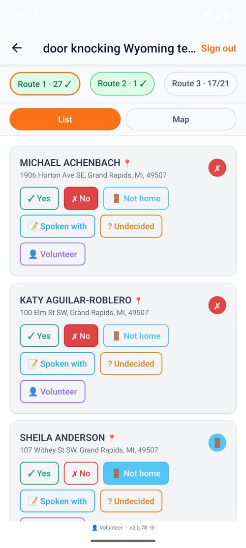
- Doors ranked by Buyer ScoreKnock the homes most likely to say yes — first.
- One-tap door loggingYes, No, Not home, Lead — captured in a single tap.
- Works fully offlineDead zones don't stop the shift. It syncs when signal returns.
- Live team mapEvery knock on the manager's board in real time.
Trusted by field teams across industries
Optimized GPS routes eliminate backtracking and wasted time between stops.
Our geocoding engine processes millions of addresses with industry-leading accuracy.
Powered by CSV2Geo with accuracy scoring other platforms don't offer.
Everything Your Field Team Needs
From route planning to real-time sync, we handle the logistics so your team can focus on conversations.
Optimized Walking Routes That Save Hours
AI-powered route optimization eliminates backtracking. Your canvassers hit more doors in less time with turn-by-turn walking directions and real-time GPS tracking.
- Automatic route optimization by proximity
- Left/right side of street splitting
- Offline mode for poor signal areas
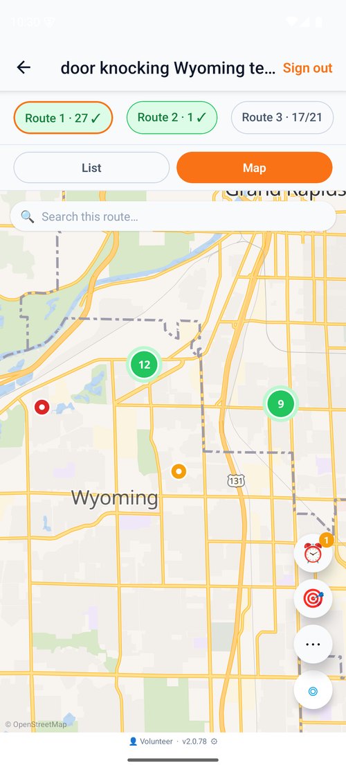
See Your Entire Team in Real Time
Track every canvasser's location, assigned territory, and completion progress from one dashboard. Reassign routes on the fly. No more overlapping coverage.
- Live canvasser locations on the map
- Role-based permissions (Admin, Co-Admin, Staff)
- Door response tracking and sync
1,000+ APIs Power Every Door Knock
Enrich your data with property values, demographics, risk scores, and more — all powered by CSV2Geo's massive API network. Know who lives behind every door before you knock.
- Geocoding across 246 countries
- Property values, owner info, and risk data
- Accuracy scoring on every geocoded address
Print-Ready Maps Your Team Can Hold
Not every canvasser wants an app. Generate beautiful PDF walk lists with maps, voter details, custom checkboxes, and color-coded markers. Works without internet, battery, or training.
- Customizable entries per page
- Color-coded markers by priority
- Unlimited regenerations from one data file
One Platform. Every Field.
Whether you're knocking doors for votes, sales, policies, or roofs — WalkLists adapts to your workflow.
Political
Voter file management, precinct walk lists, canvasser tracking, and door-to-door response recording.
Sales
Territory management, lead scoring, door-to-door route optimization, and real-time team dashboards.
Insurance
Property data enrichment, risk scoring, neighborhood targeting, and policy acquisition at scale.
Roofing
Storm damage targeting, property age filtering, neighborhood canvassing, and first-to-door advantage.
Every door, straight into your CRM
Send new contacts and door results into HubSpot, Google Sheets, Slack and 7,000+ apps through Zapier — plus real-time webhooks and a REST API. The moment a rep taps it, not a nightly export.
Or anything that accepts a webhook or calls an API.
Teams That Knock Smarter
Hear from field teams who transformed their operations with WalkLists.
“We increased our door-knock rate by 40% in the first week. The GPS routing alone saved us 2 hours per canvasser per day.”
“Our reps used to waste half the day figuring out where to go next. Now they just follow the route. Pipeline grew 3x in one quarter.”
“The data enrichment is unreal. We know property values, roof age, and owner info before we ever knock. Every door is qualified.”
Ready to Transform Your Field Operations?
Join thousands of field teams who knock smarter, not harder. Start for free — no credit card required.
Frequently Asked Questions
Everything you need to know about getting started.